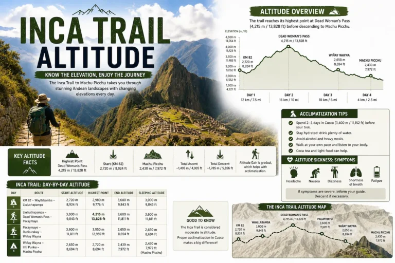
The elevation of the Inca Trail varies as you traverse the various landscapes on your way to Machu Picchu. The highest point on the trail is known as the Dead Woman’s Pass (Warmiwañusqa), which reaches an altitude of approximately 4,215 meters above sea level.


The elevation of the Inca Trail varies as you traverse the various landscapes on your way to Machu Picchu. The highest point on the trail is known as the Dead Woman’s Pass (Warmiwañusqa), which reaches an altitude of approximately 4,215 meters above sea level.
Here’s a general breakdown of the elevations at key points along the classic Inca Trail:
- Start (Kilometer 82): Around 8,923 feet (2,720 meters)
- First Camp (Wayllabamba): Approximately 9,840 feet (3,000 meters)
- Second Camp (Pacaymayu): Around 11,800 feet (3,600 meters)
- Dead Woman’s Pass (Warmiwañusqa): The highest point at about 13,828 feet (4,215 meters)
- Third Camp (Wiñay Wayna): Approximately 8,692 feet (2,650 meters)
- Inti Punku (Sun Gate) and Machu Picchu: Around 7,972 feet (2,430 meters)
These elevations give you an idea of the varying altitudes along the Inca Trail. Altitude acclimatization is an important consideration for trekkers, and it’s recommended to spend some time in a high-altitude location, such as Cusco, before starting the trek to help reduce the risk of altitude sickness.